File:Europe in 1812.PNG
Jump to navigation
Jump to search
No higher resolution available.
Europe_in_1812.PNG (536 × 399 pixels, file size: 458 KB, MIME type: image/png)
Summary
| Description |
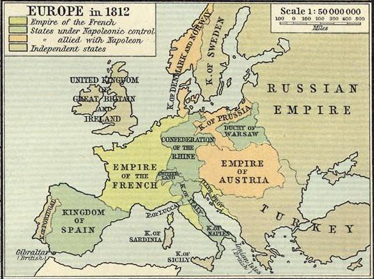
English: Political map of Europe in 1812, showing boundaries immediately prior to Napoleon's invasion of Russia |
||||||||||||||||||||||
| Date | |||||||||||||||||||||||
| Source |
Historical Atlas. New York: Henry Holt and Company copy available at http://www.lib.utexas.edu/maps/historical/history_shepherd_1911.html |
||||||||||||||||||||||
| Author |
|
||||||||||||||||||||||
Licensing
This media file is in the public domain in the United States. This applies to U.S. works where the copyright has expired, often because its first publication occurred prior to January 1, 1929, and if not then due to lack of notice or renewal. See this page for further explanation.
|
 | |
 |
This image might not be in the public domain outside of the United States; this especially applies in the countries and areas that do not apply the rule of the shorter term for US works, such as Canada, Mainland China (not Hong Kong or Macao), Germany, Mexico, and Switzerland. The creator and year of publication are essential information and must be provided. See Wikipedia:Public domain and Wikipedia:Copyrights for more details.
|
File history
Click on a date/time to view the file as it appeared at that time.
| Date/Time | Thumbnail | Dimensions | User | Comment | |
|---|---|---|---|---|---|
| current | 16:58, 28 January 2009 | | 536 × 399 (458 KB) | R'n'B | {{Information |Description={{en|1=Political map of Europe in 1812, showing boundaries immediately prior to Napoleon's invasion of Russia}} |Source=Historical Atlas. New York: Henry Holt and Company copy available at http://www.lib.utexas.edu/maps/historic |
Pages using this file
The following 2 pages use this file: